Optical Character Recognition of Handwritten Texts
Anders Brun, Ewert Bengtsson, Fredrik Wahlberg, Tomas Wilkinson, Kalyan Ram
Partners: Lasse Mårtensson, Dept. of Scandinavian Languages, UU; Mats Dahllöf, Dept. of Linguistics and Philology, UU
Funding: Faculty of Languages and Humanities, UU
Period: 1008-
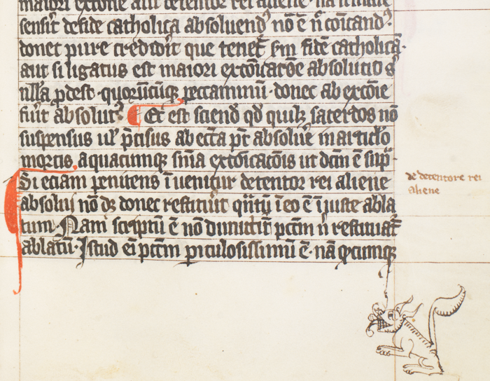
Abstract: Optical character recognition (OCR) is still, after nearly 100 years of research, an active area of research. Currently one of the frontiers is the recognition of handwritten text (HTR), in particular from historical documents, see Figure 27. This year, two PhD students were recruited. Bojana Simsic was hired to do part-time work on marketing. The project participated in the book fair Bokmässan in Gothenburg and was featured several times in articles and on national TV. In late 2013, the project started to collaborate with The Swedish Museum of Natural History, to help out with digitization of herbarium sheets.
|
GeoMemories
Anders Hast
Partners: Andrea Marchetti, Salvatore Minutoli, Alessandro Prosperi, Alessandro Lugari, Maurizio Tesconi, Beatrice Rapisarda, Matteo Abrate, Clara Bacciu, Davide Gazzé, Sergio Bianchi, Istituto di Informatica e Telematica (IIT), Pisa, Italy
Abstract: The GeoMemories project is aimed at making publicly available, through web access, heritage preserved in the archives of Aerofototeca Nazionale in Rome, which contains photographs covering the Italian territory from the end of 1800 till modern days. The web application is based on google earth but oriented towards the management of the temporal variable, so that geospatial changes can be monitored over time. The historical aerial photos need to be digitized, illumination corrected, orthorectified, georeferenced and finally stitched together.
Anders Hast spent one year (2011) at IIT, CNR in Pisa Italy as an ERCIM fellow working with image processing and computer vision aspects in the project. Since returning to UU in January he is a research associate at IIT, CNR and continues working with the project.
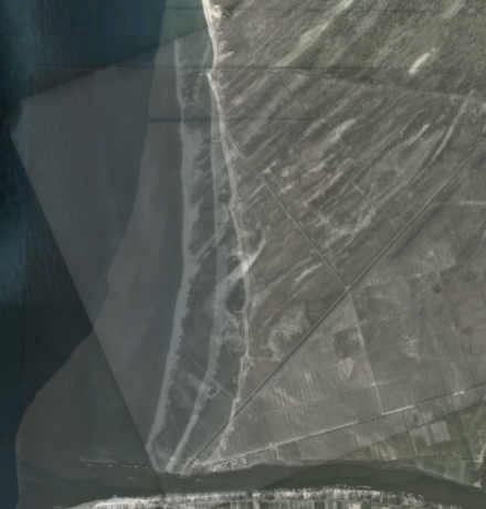
During 2013 three papers were published, whereof two journal papers and one conference paper. One of the journal papers describes the GeoMemories application and the image pipeline being used, and was accepted in a Special Issue "Geospatial Monitoring and Modelling of Environmental Change" of the ISPRS International Journal of Geo-Information. The title is "Geomemories - A Platform for Visualizing Historical, Environmental and Geospatial Changes of the Italian Landscape". The Figure 28 is taken from that paper and shows how the application can be used to monitor environmental changes. About 400 meters of the shore line outside Pisa has disappeared since 1943, and even more since 1765 (cadastral map).
|
Image Analysis for Landscape Analysis
Anders Brun
Partners: Bo Malmberg, Michael Nielsen, Dept. of Human Geography, Stockholm University; Anders Wästfelt, Dept. of Economics, SLU
Funding: UU/SU
Period: 0901-
Abstract: This project is a collaboration with researchers at SU and SLU. It aims to derive information about the landscape (rural and city) from satellite images. The project focuses on using texture analysis of images rather than only pixelwise spectral analysis to segment the image into different meaningful regions. One journal manuscript has been submitted during 2013 and we have started a collaboration with the GLEAN project and the department of Political Science at Stockholm University.
Dual-domain Visual Exploration of Urban Solar Potential
Stefan Seipel
Partners: Joakim Widén, David Lingfors, Solid State Physics, Dept. of Engineering Sciences, UU
Funding: University of Gävle; TN-faculty, UU
Period: 1211-
Abstract: This project aims to improve the planning and design of solar electricity installations in the urban environment. One major objective of these studies is to enable a highly detailed temporal and spatial analysis of the expected solar yield, which becomes increasingly important for optimal load balance in electric power networks. In our research we develop a 3D simulation model that integrates geographical data and detailed 3D urban models with temporal solar irradiance and climate data. According to our model the predicted solar yield becomes a multi-dimensional function of several design-specific parameters that are interactively explored by a human expert. This project is an interdisciplinary initiative that involves researchers from Energy Systems and from Computer Science at UU and the University of Gävle. During the first year, a demonstrator system for the interactive exploration of the design parameter space has been developed. Our method and the demonstrator system have been published in two international conferences in 2013. Forthcoming research in this project will concern the refinement and validation of computational models, as well new methods for interactive visual exploration.
Automatically Determining Road Condition with a Camera
Cris Luengo
Partners: Pertti Kuusisto and Jonas Hallenberg, the Swedish Transport Administration (Trafikverket), Borlänge.
Funding: The Swedish Transport Administration
Period: 1303-1307
Abstract: We performed a pre-study on the possibilities to automatically determine road
conditions (dry, wet, icy, snow-covered, etc.) using only images obtained from
the network of road monitoring cameras that the Swedish Transport Administration
has set up throughout the country. Currently, these images are sent to a central
location where personnel examines them. Automating this task is desirable for
several reasons, including more frequent updates of road condition that would
be possible if the images do not have to be sent to a central location. The
pre-study included a literature review and an interview with a Swedish
researcher working in the field.
Tracking Honey Bees and Their Interactions
Cris Luengo
Partners: Olle Terenius, Ingemar Fries, Joachim Rodrigues de Miranda, Eva Forsgren, Barbara Locke, Dept. of Ecology, SLU; Fredrik Liljeros, Dept. of Sociology, Stockholm University
Funding: Åke Wiberg foundation; and S-faculty, SLU
Period: 1003-
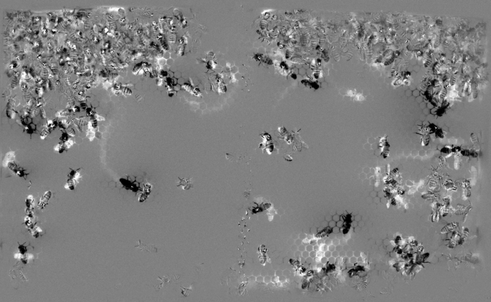
Abstract: In this project, we are creating a system in which we can observe a portion of a bee hive (containing about one thousand individuals, each tagged with a unique identifier on its back) over days or weeks. Bees will be free to enter and exit the hive, and the environment will be set up to be as natural as possible for the bees. The purpose is to observe the natural behaviour of the bees, and record the type and duration of interaction between individuals. In 2013, Iulian Florea finished his MSc thesis within this project, developing and testing real-time algorithms to process video, including background removal,
tracking and detection (Fig. 29). He also established a good video compression protocol to be used in future experiments.
|
Fish Type Recognition in Underwater Videos for Sustainable Fishing
Vladimir Curic, Ida-Maria Sintorn
Partners: Arne Fjälling, SLU Aqua, Stockholm
Funding: Graduate School in Mathematics and Computing
Abstract: This projects investigates whether is possible to construct a system, which can determine the fish type using the underwater camera mounted in the tube at the end of the fishing trap (Fig. 30). The result of the image analysis will signal to the ramp at the end of the tube to either catch the fish or return the fish to a sea. Wild salmon are caught, bred, and planted back in the sea. To distinguish between wild and farmed salmon, each farmed salmon is marked by cutting off the adipose fin on the back of the salmon. Sustainable fishing is performed in a way that the farmed salmon should be caught, while the wild ones should be released back into the sea. The goal of the project is also to separate salmon from sea trout using texture and morphometric measurements.
DIPimage and DIPlib
Cris Luengo
Partners: Bernd Rieger, Lucas van Vliet, Quantitative Imaging Group, Delft University of Technology, The Netherlands; Michael van Ginkel, Unilever Research and Development, Colworth House, Bedford, UK
Funding: S-faculty, SLU
Period: 0807-
Abstract: DIPimage is a MATLAB toolbox for scientific image analysis, useful for both teaching and research (http://www.diplib.org). It has been in active development since 1999, when it was created at Delft University of Technology. In 2008, when Cris Luengo moved to Uppsala, CBA was added to the project as a main development site. DIPlib, created in 1995, is a C library containing many hundreds of image analysis routines. DIPlib is the core of the DIPimage toolbox, and both projects are developed in parallel. Because DIPlib provides efficient algorithms, MATLAB is useful for image analysis beyond the prototyping stage. Together, MATLAB and DIPimage form a powerful tool for working with scalar and vector images in any number of dimensions. Version 2.5 was released in 2013, and improved the speed of image skew and rotation operations, the Fourier transform, and the reading of time series from disk; it also added some minor features and fixing some bugs. We also implemented the option to do arithmetic operations without changing the data type of the image, useful when working with very large images. This last change will appear in the next release.
UPPMAX Cluster Computing
Martin Simonsson, Carolina Wählby
Partners: Hans Karlsson, Elias Rudberg, Ola Spjuth, UPPMAX
Funding: SciLife Lab Uppsala; eSSENCE; Dept. of IT, UU
Period: 1110-
Abstract: Life science applications generate a huge amount of image data that has to be stored and analysed in an efficient way. This project
is focused on providing easy access to high-performance computers and large-scale storage. In collaboration with Uppsala Multidisciplinary Center for Advanced Computational Science (UPPMAX) image analysis software are being installed and maintained on the cluster. Database solutions with easy web access to image data are also being developed and maintained. This project has also provided workshops and seminars to help life science researchers to get started and use the resources.In the end of 2013 we initiated our first large-scale image analysis project using the computer cluster working with 900 000 images from drug screening project.